City2Surf Course Map 2025
By Visit Bondi Beach Editorial Team · · Updated
Part of our City2Surf & running guide.
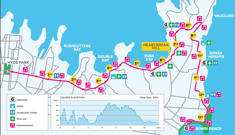
Here's the City2Surf route the way I'd walk you through it as a local - from the CBD start to the Bondi finish, with the one climb everyone worries about put in its place. For the official downloadable map with water stations and split points, head to city2surf.com.au; what follows is the lay of the land so it isn't all a surprise on the day.
- Next race
- Sunday 8 August 2027
- Distance
- ~14 km (13.9 km)
- Start
- Park & College St, Sydney CBD
- Finish
- Queen Elizabeth Dr, Bondi
- Total climb
- ~221 m elevation gain
- Big climb
- Heartbreak Hill (~2 km, from ~6 km in)
The course, section by section
- Start - beside Hyde Park at Park and College Streets, then a fast downhill along William Street.
- Kings Cross - through the tunnel and out toward the harbour; this early stretch is quick, so don't get carried away.
- Rose Bay - along New South Head Road beside the water. Enjoy it, because the hill is next.
- Heartbreak Hill - a roughly 2 km climb up New South Head Road from Rose Bay to Vaucluse, starting about 6 km in. It sits around halfway and it's the toughest part of the day.
- Vaucluse to the coast - onto Old South Head Road and Military Road, with a few short sharp pinches before a rewarding downhill and big ocean views.
- Bondi finish - a turnaround near Curlewis Street and roughly a final kilometre of flat switchback to the line on Queen Elizabeth Drive above the beach.
Best spots to watch - or push hard
Rose Bay and the foot of Heartbreak Hill are my favourite places to spectate; the crowd support there genuinely carries runners up the climb. If you're racing, treat the crest at Vaucluse as your cue to reassess your pace, and save something for that sneaky final switchback at Bondi before you spend everything.
Frequently asked questions
Where can I get the official City2Surf course map?
From the official site, city2surf.com.au, which publishes the current downloadable map with water stations, drink stations and split points.
Where does the City2Surf start and finish?
It starts beside Hyde Park in the Sydney CBD (Park and College Streets) and finishes on Queen Elizabeth Drive above Bondi Beach, close to 14 km later.
How hard is Heartbreak Hill?
It's a roughly 2 km climb along New South Head Road from Rose Bay up to Vaucluse, beginning about 6 km into the race and gaining around 75 m. It's the steepest sustained section, but there are also several shorter rises after it before the downhill run to Bondi.
Is there an official City2Surf course map PDF I can download?
Yes - the event publishes an official downloadable course map at city2surf.com.au each year, and that is the copy to trust for road closures and village layouts. Our section-by-section walkthrough above tells you what each part of that map actually feels like to run.
Can I get the route as a GPX file or follow it on Google Maps?
The official interactive map at city2surf.com.au is the reliable source, and running platforms like Strava carry the course from previous years’ activities if you want a GPX to study. One caveat: on race day the 14 km route runs on closed roads, so regular Google Maps navigation will not follow it - use the official map on the day.